

© Otto Lowe for Factum Foundation
Over a period of twelve days during the summer of 2020, while the Covid-19 pandemic offered an exceptionally quiet and empty Venice, Factum Foundation and the Fondazione Giorgio Cini recorded the island of San Giorgio Maggiore. The aim was to demonstrate that technologies such as aerial and ground-based photogrammetry and LiDAR recording could eventually be used to record the whole of Venice. The island was recorded by a team of five people from more than 600 different stations, generating a massive 60,000-million point-cloud. Point-clouds of large areas, which are generated by LiDAR laser scanners, can be merged with higher-resolution photogrammetry data of more localised areas to create a 3D model of the whole island – it is hoped that further financial support for the project will enable this to happen.
Since 2020, the work carried out on the island has found direct applications for the study and monitoring of the speed of the salt damage to the stucco walls of the cloisters of San Giorgio Maggiore. The data has been used to generate a restoration program for the external surfaces of the building and the presidential rooms, as well as facilitating a detailed study of the furniture in the Cini’s collection. As the recording of both the island and its contents continues, it will make remarkable collections of the Fondazione Giorgio Cini increasingly open and accessible. As new technologies are developed and refined, we will be able to gather increasingly detailed, data which will enhance the entire field of study and research.

Tonal map image of the island © Factum Foundation for ARCHiVe
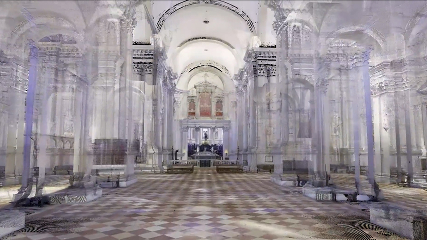
Basilica of San Giorgio Maggiore


Recording the façade of the Basilica of San Giorgio Maggiore © Otto Lowe for Factum Foundation

Render of the façade of San Giorgio Maggiore © Factum Foundation for ARCHiVe

© Factum Foundation for ARCHiVe

First (right) and final (right) data processing of the render of one the statues on the façade © Factum Foundation for ARCHiVe

Recording the altar inside the Basilica of San Giorgio Maggiore © Otto Lowe for Factum Foundation

3D model of the San Giorgio Maggiore altar © Factum Foundation for ARCHiVe


Point-cloud render of the apse © Factum Foundation for ARCHiVe

Francesco Cigognetti recording the altar and the lectern © Otto Lowe for Factum Foundation

3D model of the lectern © Factum Foundation for ARCHiVe

3D model of the altar and the lectern © Factum Foundation for ARCHiVe

Point cloud of the inside of the flooded crypt © Factum Foundation for ARCHiVe
Longhena Staircase and Refectory

Pedro Miró and Emanuele Zampieri recording the Longhena Stairs © Otto Lowe for Factum Foundation

Individual details were recorded using photogrammetry © Otto Lowe for Factum Foundation

The data acquired using photogrammetry was merged to the LiDAR dataset, creating a 3D model of the Longhena Stairs © Factum Foundation for ARCHiVe

Render of the Longhena staircase © Factum Foundation for ARCHiVe

Render of the Longhena staircase © Factum Foundation for ARCHiVe
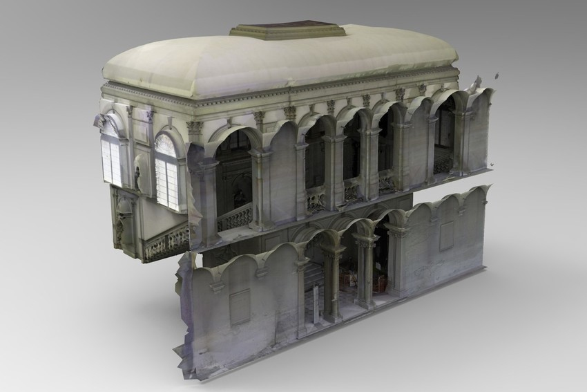
Render of the Longhena staircase © Factum Foundation for ARCHiVe
Point-cloud render of the Longhena staircase © Factum Foundation for ARCHiVe
Video of the first processing of the 3D model of the Longhena Staircase © Factum Foundation for ARCHiVe

3D model of the palladian refectory of San Giorgio, housing Factum Arte’s facsimile of ‘The Wedding at Cana’ by Veronese since 2007. The floor uses data taken from a 2015 recording of the Longhena Staircase floor tiles © Factum Foundation for ARCHiVe

Pedro Miró recording the library with a LiDAR scanner © Otto Lowe for Factum Foundation

3D model of the Sala del Soffitto’s ceiling without colour (left) and with colour (right) © Factum Foundation for ARCHiVe
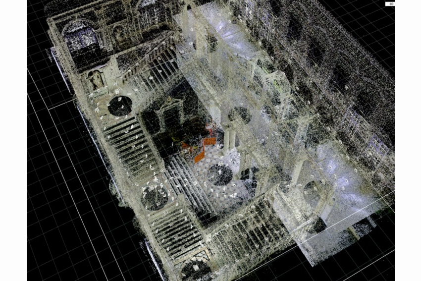
Cloister, Borges Labyrinth and gardens

Point cloud of the cloister of San Giorgio Maggiore © Factum Foundation for ARCHiVe

Point cloud of the damaged walls of the cloister © Factum Foundation for ARCHiVe
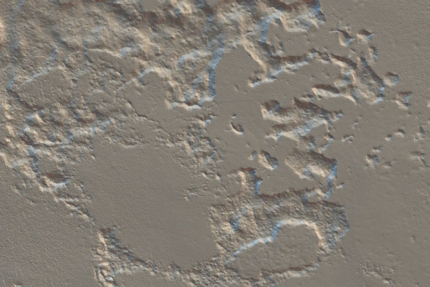
(Detail) Point cloud of the damaged walls of the cloister © Factum Foundation for ARCHiVe

Monitoring the salt damage in the cloister © Factum Foundation | ARCHiVe

Point cloud of the Borges Labyrinth © Factum Foundation for ARCHiVe
3D model of the bust of Ezra Pound by Henri Gaudier-Brezka (authorized copy by Isamu Noguchi), one of the contemporary sculptures in the Fondazione Cini’s courtyards © Factum Foundation for ARCHiVe
Monitoring the Lagoon waters with Divirod
Following a radio programme on the ARCHiVe project, discussing the digitisation of the Island of San Giorgio Maggiore in Venice (The World, September 2020), Factum Foundation was contacted by Divirod, a tech start-up from Boulder, Colorado.
Divirod has developed a passive radar sensor that uses satellites and locally recorded data to generate accurate hydrological models. The software transforms harmonic resonances into dynamic representations of tide, wave activity and wind speed to predict erosion and flooding. Divirod has provided various examples of advanced sensors to monitor the relationship between land and water on the island, with the data accessible in real-time on desktop and mobile devices.
In late August 2021, ARCHiVe installed the first Divirod sensor to enable the study and documentation of the natural changes on and around the island. The advanced sensor installed in Venice detects the unique signature of satellite signals bouncing off the water of the Lagoon. This provides a local, accurate and dynamic image of the relationship between a fixed point on the land and the water. The data is uploaded to the cloud in real-time, where machine learning software developed by Divirod compiles and processes it. The accurate hydrological models generated from the harmonic recordings are used to create constantly updating representations of the tide, wave activity and wind speed, to predict erosion and flooding. As more sensors are installed, our understanding of the relationship between land and water will continue to deepen. Indeed, though the latin ‘terra firma’ defines the land by its solidity and firmness, it is in slow but perpetual motion, while water is a truly dynamic fluid, animated by everything from gravity to speedboats. As ARCHiVe’s study progresses, we hope to further investigate the interplay between land and water, so characteristic of the cultural heritage of Venice.
A second sensor was installed in February 2022 on the north-eastern point of the island. As the sensors start to log vast quantities of dynamic information, Factum Foundation and Divirod will be working with the Cini Foundation to find new applications and develop tools that will help provide answers to practical needs, such as the extraction of information about salinity and temperature.

The second sensor installed on the North-Eastern point of San Giorgio Maggiore © Fondazione Giorgio Cini

The second sensor installed on the North-Eastern point of San Giorgio Maggiore © Fondazione Giorgio Cini
Press features:
– On Digital Technologies, Our Cultural Heritage and Global Warming. How do they come together in Venice? (British Library, October 2021)
– Venezia, l’isola di San Giorgio diventa digitale (Repubblica, September 2021)
– Venecia se inunda, y la tecnología de este ingeniero español ayudará a saber a qué velocidad para prevenir posibles daños al patrimonio (Business Insider España, September 2021)
– Sunken Treasures (Project Management Institute, March-April 2021)
– Cutting-Edge Technologies are being used to help save Venice (Architectural Digest, October 2020)
– New technologies might save Venice’s cultural heritage from the floods (ArchDaily, October 2020)
– Preserving the floating city of Venice digitally (The World, September 2020)
– New laser-scanning project will allow Venice to live on forever as a digital avatar (The Art Newspaper, September 2020)
– La Magnifica Preda (Il Giornale dell’Arte, September 2020)
– Un visionario sull’isola di Borges (Il Giornale dell’Arte, Vernissage, July-August 2020)


